Sunday, October 14, 2012

Top 5 US National Parks - #3 Grand Teton

Before moving down to LA from the Bay Area to begin my Master of Public Health program at UCLA, Allyson and I decided to take a road trip for almost a month (July 16 through August 9, 2009). We traveled through 7 states, including California, Nevada, Idaho, Wyoming, Montana, Washington, and Oregon. We visited 4 national parks, including Grand Teton, Yellowstone, Glacier, and Crater Lake. On top of that, we were in multiple national forests and state parks (including Mt. Hood National Forest and Moran State Park). Needless to say, we finished this trip with many road and trail miles under our belts, pint glasses from many breweries we hit up along the way, and many, many wonderful memories (and a few not-so-great memories like our car not starting in Glacier National Park with no cell phone reception). Grand Teton National Park was the first one on our trip, and it might have been my favorite. We saw a lot of this park, but there is so much more to see. I definitely hope we can make another trip back there some day!

We arrived in Grand Teton National Park mid-day and checked into our campsite at Gros Ventre campground. I highly recommend this campground if you don't want super crowded. Also, you can walk a little way through the trees, right from your campsite, to the Gros Ventre River. Yes, it's cold. But it was so fantastic to rinse off after a couple days of driving.

The first of many bison we saw right from the car!

Our original plan had been to do the Cascade Canyon/Paintbrush Divide Loop, but some of the higher elevation parts of the loop were still completely snowed in. Without the proper equipment, we didn't feel prepared to tackle the snow. Instead we planned to hike up Cascade Canyon Trail, first head north to Lake Solitude (9.4 miles), then head back the other way going south to Hurricane Pass (8.3 miles), and eventually head back out Cascade Canyon (12.3 miles). 

On Day 1, we started off at String Lake Trailhead, and worked our way through a burned forest along the shores of Jenny Lake to Hidden Falls (about 2.2 miles) and Inspiration Point. Many tourists take a shuttle boat across the lake, and then it's a very short hike to the falls. Therefore, the falls are busier than most backpackers would like. We got there pretty early in the day, so it wasn't too bad. 
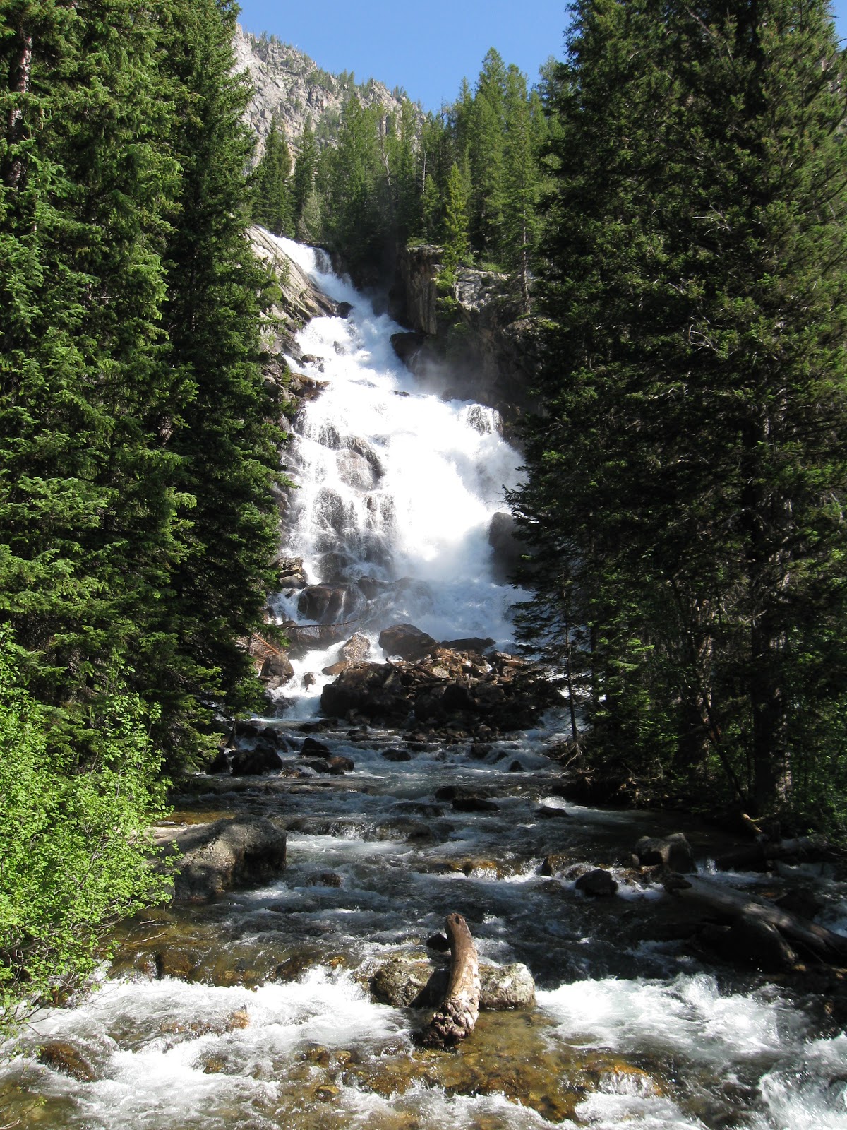
Hidden Falls

Jenny Lake from Inspiration Point

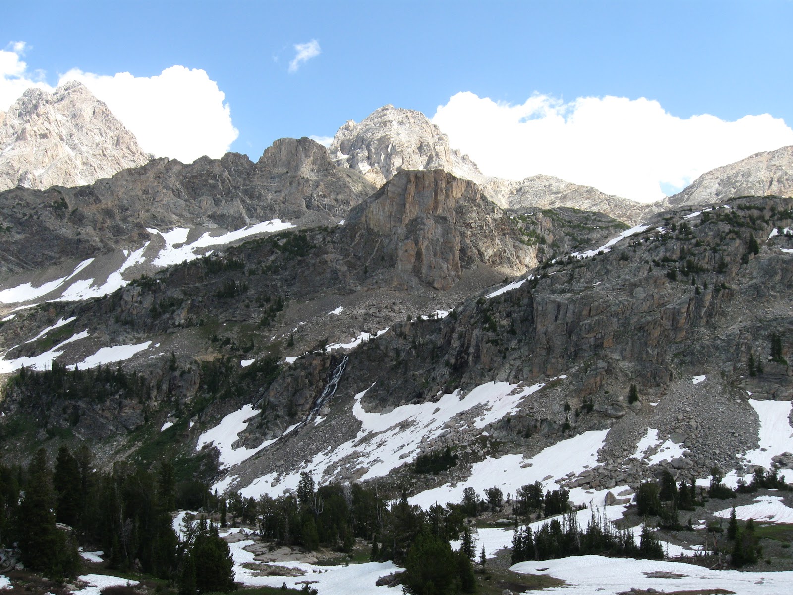
All of Cascade Canyon is breathtaking, with lots of great spots to stop for lunch. Below is where we stopped for lunch. We walked to a little sand bar in the middle of the river to sit and eat lunch. After lunch, we continued up the trail and then headed north on North Fork Cascade Trail. 

Our lunch spot along Cascade Canyon Trail


Lake Solitude (elevation 9035 ft)

 Chillin at our campsite in the North Fork Cascade camping zone

 Pica! We could hear these little guys the whole time we were hiking on the North Fork Trail.

 On Day 2, we took North Fork Cascade Trail back the way we came and then continued onto South Fork Cascade Trail. We got all the way to Hurricane Pass, but then it was pretty snowed in. We found the most incredible campsite that I think I've ever seen at the edge of a cliff at about 10,000 ft elevation and then took our packs off and explored the area a bit.

When we got back to the site, the sky had completely changed and we started hearing thunder. This may have been the most terrifying night of my life. Yes, our campsite was awesome because we were right at the edge of a cliff and could see views in all directions. And yes, our campsite was really not the best place to be during a thunderstorm (there were even a couple of trees on the site that showed evidence of previous lightning strikes.) We hid in our tents for the rest of the night. Me with my eyes closed tight and trying to follow conflicting instructions I'd heard about what to do in a lightning storm. Allyson with her eyes wide open watching the tent light up from every direction and praying that we didn't get struck. I can't really tell you when the storm finally passed because it felt like I was freaking out in the tent for days. However, we made it and the next day was as beautiful as the last.


A storm's a brewin'

Glacier Lily

After the backpacking trip, we ended up getting a campsite at Colter Bay Village. This was basically like Disneyland. It wasn't bad because we were so tired, it was nice to get a shower and eat some real food at the little restaurant there. However, it's always hard to be back around that many people after seeing so few for a few days. 

The next day, we wanted to take it easy but also make the most of our last day in the Grand Tetons. We got up early and hit up a few spots that are considered "must photograph" spots. At the time, I only had my $100 point and shoot camera. Even with that, you can see why these are deemed great photograph locations.


Schwabacher's Landing

Snake River Overlook (If this looks familiar, Ansel Adams took his famous photograph from this exact location!)

Before heading up to Yellowstone later that day, we took the moderate 6.4 mile Two Ocean Lakes hike. It didn't feel that moderate being as tired as we were, but the views were outstanding and the wildflowers were absolutely incredible (as were the bugs). 


Up Next: Zion National Park (#2) and Joshua Tree National Park (#1 because it's where everything started with Allyson and me and there is just something completely unique and special about this place!)


Wednesday, October 3, 2012

Top 5 US National Parks - #4 Sequoia National Park

I really should not have made this a top 5 list. I keep thinking of additional national parks that I would like to include. Also, there are some parks, like Yosemite, that I haven't taken pictures in for a very long time but still rank up there as possible favorites. However, I do have pictures from the trip Allyson and I recently (well, two years ago now) took to Yosemite's neighbor, Sequoia National Park. It was a short weekend trip, so we planned on just camping and doing some day hikes. We got there on Friday night, and all the campgrounds were full. They directed us to a road way north of the entrance (I think it was the road you take to Big Meadows campground, but I can't be sure) where you can just pull over and camp. Because we got there so late and it was pitch black, we spent the first night just sleeping in the back of my S10 pickup. The second night we got the same "site" and pitched our tent. If you are cool without bathrooms, I highly recommend figuring out where this is. No crowds and super quiet. 

On Saturday, we hiked the 14 mile round trip hike to the top of Alta Peak (elevation 11, 204 ft). The thing I remember most about this hike was the ever-changing weather. I'm currently reading Wild, by Cheryl Strayed, and am reminded of the unpredictability of the weather in the Sierras. It can be hot and sunny one minute, and freezing mist the next. That's exactly what we got this day, but it just made it that much more exciting! We could actually watch the storms coming across the mountain range, as you can see from the pictures below. 


I'm going to be honest. This hike wore us out. But those are the days I love the best. When you are so worn out and maybe didn't eat quite enough on the trail, so what do you do? You find the pizza place in the national park, that's what! Stony Creek Lodge has a pizza restaurant with outdoor seating. Perfect after a long day of hiking, and only a few minutes from the spot we were camping. 

Our "campsite"


The next morning, we did the touristy hikes, like the General Sherman Trail and Moro Rock (amazing views of the area we had hiked the day before). Both are worth getting out of your car and taking a walk. Moro Rock is pretty challenging but short, and the trails around General Sherman and the other big trees are easy to moderate with some paved trails. 


On Sunday afternoon, we headed back to Los Angeles via Highway 198 West and stopped for lunch along a rushing river at the Gateway Restaurant & Lodge. Lunch was decent and it was a great place to finish up a wonderful weekend outdoors.

Tuesday, September 25, 2012

Top 5 US National Parks - #5 Glacier National Park

Over the course of the next couple weeks, I'm going to take some time going back through some of my old photos from trips Allyson and I have taken to the many beautiful national parks in the US. This won't be in order of my favorites, because I can't possibly pick a favorite. My friend, Garrett, will have a heyday with this post. He teases us that we only ever travel to national parks. It is true that I prefer wilderness to city adventures, but I do appreciate both. But it's in the wild that I feel connected to both nature and people. Like I'm part of something bigger. 

So here we go....#5 is Glacier National Park. It's so far away from where most of us live, which is probably why it's still so incredible. It is definitely worth being on your bucket list though. There are day hikes for those that don't want to backpack. The Going to the Sun Highway through the park might be the most beautiful road in the world. (We'll see...I have a feeling we'll see some pretty spectacular roads in New Zealand.) But it's the more remote places that really blew me away. Here are some of the highlights from the trip we took to Glacier with our friends Jess and Dani:

For our first two nights, we camped at Two Medicine Campground. We took a great hike up Pitamakan Pass. If the weather had cooperated, we would've continued the loop to Dawson Pass. Unfortunately, we got freaked out by some creepy clouds and thunder and thought it was best to turn around. Still an amazing hike though with some of the best views I've ever seen!

Take a swim, if you dare, in Old Man Lake. It took our breath away, but felt so refreshing!

 Bear Grass (Interesting fact: These flowers are closely related to lilies!)

I don't know what this one is called, but he looks straight out of The Lorax to me. (Another interesting fact: I was the Lorax in a middle school play.)

Pitamakan Overlook

Our next adventure started a little late in the day, because Allyson and I decided to re-trace a good portion of our Pitamakan Pass hike the next morning in search of my lost Oakley sunglasses. She had gotten them for me as a gift right before our trip. Unfortunately, after re-tracing to the last place I remember having them, we didn't find them. Then we still had 8.1 miles to hike to our campsite at Red Eagle Lake. 

This hike was incredible, despite the downpour for the second half of it. This whole forest burned down in 2006, and we were there in 2009. As you can see from the pictures, it still looked very much burned. But there was something truly incredible about all the wildflowers coming up beneath these dead trees. 

The storm is coming

Rebirth

We ended up setting up camp in the pouring rain and spending hours in our tents. However, the rain left during the night and left a beautiful day for us the following day. We left our stuff at Red Eagle Lake and hiked to Triple Divide Pass. This was the day we saw a moose and hiked 16 miles in Chacos or Crocs or Keen sandals because or hiking boots were still soaked. 

The morning after

Moose!

Awesome swimming spot...jump in and let that water take you away. Super fun. 


Fleabane (This was taken with my first point and shoot camera. I'm not sure I've taken a better picture since.)

We hiked out the following morning and planned to spend the next two nights at Fish Lake campground on the other side of the park. This meant a gorgeous drive down the Going to the Sun Highway. The following day we hiked the acclaimed Highline Trail. This is a long day hike (11.6 miles to The Loop from the Visitor Center and then you take a shuttle back), but totally worth it. And get this, you can have a Diet Coke on the top at Granite Park Chalet. Check out what might as well be a Diet Coke advertisement below.  

Under the bridge

Obvious Glacier Action

 Grinnell Glacier can be seen if you take the Garden Wall hike straight up from the Highline Trail

 Psychedelic Paintbrush

That is the Chalet in the right top corner of the photo

Diet Coke Ad

How cute is this deer?

So many more stories could be told about this trip (for example, the fact that our car wouldn't start on the morning we had to leave to get Jess and Dani to the Missoula airport), but we'll save those for another time. We will be back to this amazing place, because we only saw a fraction of what is there to see. Thinking back on it tonight definitely has me wanting to go back. Adventure, anyone? 


Friday, September 21, 2012

Autumn Fun in the NC (Stone Mountain State Park)

This Saturday, we are taking advantage of the fact that the humidity is gone (jumping for joy!) and heading out for a hike. We plan to check out Hanging Rock State Park, which is a little over a 2 hour drive northwest from Durham, NC. In the meantime, I am reminiscing about a great hike we took last year on a perfect fall day in the middle of October. Allyson and I, along with our friends Ciara and Beth, took a beautiful drive up to Stone Mountain State Park. The State Park is right on the Blue Ridge Parkway, which is arguably one of the best places in the country to see the fall colors.


State parks in North Carolina are amazing! The trails are always well-maintained and well-marked. Stone Mountain State Park was no exception. With a free trail map you will have no trouble finding your way back to your car. However, you may choose to extend your hike, as we did, because you are having such a wonderful time. We had planned to do the "strenuous", 4.5 mile, Stone Mountain Loop Trail. As far as I am concerned, nothing in North Carolina is strenuous. However, we did summit the mountain, all 2,305 feet of it! There is a steady climb leading up to the summit, which must be the reason for the strenuous rating, but just about anyone in reasonable shape can do this hike and enjoy it.

We started the hike at the Upper Trailhead Parking area and went clockwise on the loop trail; therefore, seeing Stone Mountain Falls first. There are great views of Stone Mountain off to the right for much of the first half of this loop. When we got to the clearing (about half way on the loop), we stopped and had lunch looking up at the climbers on Stone Mountain. After lunch, we realized we weren't ready to go back yet, so we backtracked just a bit to add on the Cedar Rock and Wolf Rock Trails. This was totally worth it! I recommend doing this no matter what, and skip the backtracking. Just turn left on the Cedar Rock Trail when you are coming down the Stone Mountain Loop Trail. There will be a great spot to stop and eat lunch right on Cedar Rock and no one will be there!


The only tricky part about the Cedar Rock/Wolf Rock loop is finding where Wolf Rock Trail starts. Once you are on Cedar Rock, head up the rock and you will find Wolf Rock Trail in the trees on your left. These two trails add on about 2.5 miles, making the whole hike about 7 miles.

I'm heading toward Wolf Rock Trail..it's in the trees to the left up there. 


After meeting back up with Stone Mountain Loop Trail, we stopped by the bathrooms at the Lower Trailhead Parking area before beginning our ascent. There were a decent amount of people enjoying the gorgeous day and trail, but not so many that we didn't have plenty of time to ourselves and plenty of space to goof around!

Near the top, there are several spots you'll want to stop to soak in the view. Mountains (more like rolling hills) as far as your eyes can see, covered in yellows, oranges, and greens. Just gorgeous!


We can't help it. It's hard not to laugh about a summit of 2,305 ft when you've climbed Mt. Whitney and backpacked in Glacier National Park. But there is something more peaceful or meditative about the Blue Ridge Mountains. We definitely appreciate their beauty, even if we joke about the summit. 


A couple cool things about this park...1. It's fairly close to Durham and a super easy drive and 2. You basically go through Winston-Salem to get there. There is a great brewery (with sweet potato fries) in Winston-Salem called Foothills Brewery. Make sure you stop there on your way home from a great day of hiking. We happened to pull into Winston-Salem right when their 1st Annual Pride Parade was taking place! It was nice to see a rather conservative town celebrating diversity. We make Foothills Brewery a regular stop on our way to or from Asheville or anything in the western part of the state.